|
So far, we have
visualized orbits in two and three dimensions, but we have not identified
where the satellite is, in relation to specific positions on the earth.
We could accomplish this by drawing a map of the earth on the sphere (in
the 3D model) and inputting the rate of rotation. However, this figure
would probably contain too much information to process, and wouldn't be
that helpful in 'seeing' the orbit position over the earth.
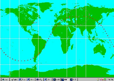
One way to tell which part of the earth the satellite is over is to flatten
out a map of the earth and trace the path of the satellite on top. There
is some nice software that does this, called WinOrbit, and it is available
for free on the Web. It already contains the orbital elements for
a number of satellites that are currently orbiting the earth, and allows
you to see where they are in 'real time.' An example of a satellite
path traced over the earth, using WinOrbit can be seen below. |