
|
|
Near the Town of Wytheville, VA, there is an 8-mile stretch of road where two major interstates, I-81 and I-77, overlap. In this area, truck traffic has recently increased from a projected 15% to up to 40%. For safety reasons, the Virginia Department of Transportation (VDOT) is currently evaluating design proposals for the re-alignment of this eight-mile stretch of roadway near the town of Wytheville, VA. For the planning and design study, the Virginia Tech Civil and Environmental Engineering Department and VTDEVELOP are working to create 3-dimensional visualizations of the existing roadway and the proposed alternatives. (For more on the overall project, see the "Wytheville Main Project Home Page")
As the project director of VTDEVELOP, I am in charge of the creation of these visualizations. This class project is an opportunity for me to investigate the usefulness of GeoView for the Wytheville scenarios. I will attempt to bring a small Digital Elevation Model (DEM) and an aerial photo of the Wytheville area into GeoView and create a GeoView User's Guide for future use.
|
|
|
|
|
|
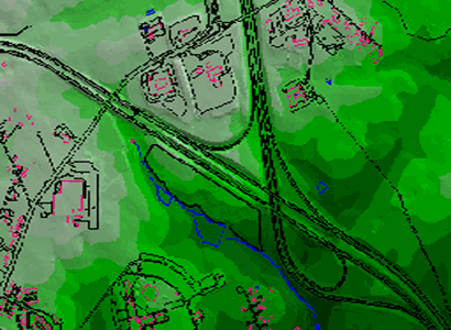
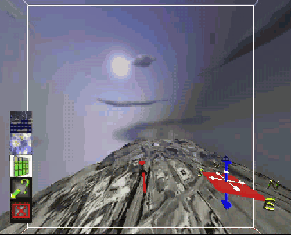
To bring the data into GeoView, a great deal of file manipulation was needed. The DEM (shown below) was originally created in ArcView GIS 3.2 using contours that were created in AutoCAD 2000. Unfortunately, the size of the DEM was too large to work with. Therefore a small portion of the DEM that is relevant to the project was isolated and rebuilt. Once the smaller DEM was created, a screen capture of the DEM with GIS lines (roads, buildings, etc...) was take for use as a texture file in GeoView. This DEM was converted to a 300x200 grid with cell size of 20 feet and exported to an ASCII file. The large cell size was chosen because GeoView can only handle grids up to 500x500 cells in size. Before the ASCII file could be used in the Unix environment to be brought into GeoView, I had to run the "crstrip" program to remove all of the Windows carriage returns (^M). The header of the ASCII file was modified to include the number of columns and the number of rows in the grid. In addition, the elevation values had to be converted to integers, and the file was saved as a .elev file. These last modifications were necessary to make the ASCII file compatible with the GeoView package.
|
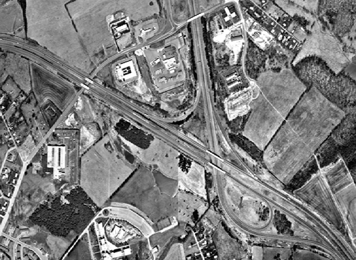
The aerial photos posed a different problem. The area chosen for the DEM consisted of four aerial photos. The first step was to mosaic these photos together using ERDAS Imagine 8.4 to create one, overall photo covering the desired area. However, because GeoView can only handle square .rgb files with sides equivalent to a power of two, the final photo was converted to a 512x512 Bitmap (.bmp) format using Adobe Photoshop and then to a .rgb format using Image View. Unfortunately, the bitmap also had to be run through the "crstrip" program to remove the carriage returns before it could be used and converted. (The original aerial photo is shown here.)
|
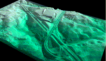
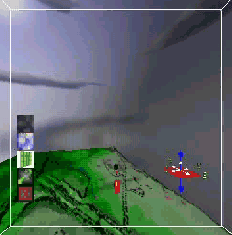
In addition to using this aerial photo as a texture file, I also took a screen capture of the DEM itself in ArcView. As shown below, the original screen capture is an overhead view of the DEM containing GIS lines such as roads, buildings, and streams. It was converted to a 256x256 bitmap using Adobe Photoshop and later converted to an .rgb file using Image View. This will be used as the second texture file in GeoView.
|
Once all of the data was manipulated, certain files used in the GeoView demo program had to be modified. The original GeoView demo includes a visualization of Morgantown, WV and uses five files for the setup. Two of these files, WVdemo.config and WVdemo.textures, were edited to indicate the correct paths to the new DEM and aerial photo. All other settings in these files were left unchanged. After these final changes were made, the WVdemo executable file was run in GeoView and the data appeared.
The final step in the project was to create the User's Manual. This was accomplished through web research of previous GeoView sites and through experience with the program itself. Included in the manual are screen captures and movies of the Wytheville data in GeoView. The final user's guide can be found using the link on the right side of this page. The movies created can be downloaded below:
 |
 |
Upon completion of this project, I have concluded that GeoView is a very useful tool for visualizing elevation data. The ability of GeoView to be used both on a desktop computer and in the CAVE makes it very versatile and dynamic. The controls are very smooth and easy to use, allowing a user to fly freely through the digital environment. In addition, the ability of the user to overlay maps and different texture files allows for in-depth analysis of GIS entities and other information. In conclusion, I hope to use GeoView on future visualizations for the Wytheville Interchange and I-81/I-77 project.
|
Prjoect Completed By: Marissa M. Gagne Graduate Research Assistant GIS & CAD Applications Via Department of Civil & Environmental Enigineering Virginia Tech mgagne@vt.edu |
 |